The Great London [Search results for Geology]
Indonesia: Biggest exposed fault on Earth discovered

Palaeontology: Africa’s earliest known coelacanth found in Eastern Cape

Environment: Scientists predict extensive ice loss from huge Antarctic glacier

Italy: Fossil find reveals just how big carnivorous dinosaur may have grown

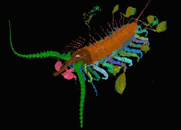
Palaeontology: Fossil of 425-million-year-old parasite found intact with its host

Geology: Extraterrestrial opal discovered in Antarctic meteorite

Geology: Copper gives an answer to the rise of oxygen

Palaeontology: Fossil bee nests provide clues about the environment in which Australopithecus africanus lived

Astronomy: Fossilized rivers suggest warm, wet ancient Mars

Chanel Islands: Jersey was a must-see tourist destination for Neanderthals for over 100,000 years

Palaeontology: Chasing after a prehistoric Kite Runner
Environment: World's largest canyon may lie under the Antarctic ice sheet

Geology: Common magnetic mineral is reliable witness to Earth's history

Geology: Signs of ancient mega-tsunami could portend modern hazard
